
Geographical location of Madhya pradesh:-
INTRODUCTION
Madhya Pradesh is commonly abbreviated as M.P. in India local. Its name “Madhya Pradesh” means “Central Region” because is if located at Central of India in plains. Till year 2000, Madhya Pradesh was the largest state of India in area-wise but after creation of Chattisgarh state from Madhya Pradesh area, it become second largest state in area-wise and 6th largest state in population wise. Is is among few states of India who shares their state border with other states of India and not with any other country or coastal line. Its north-east border touches Uttar Pradesh state, north-west border touches Rajasthan, western border touches Gujarat, south-west border touches Maharashtra state and south-east border touches Chattisgarh. Geography of Madhya Pradesh is divided into several geo-structural divisions. Medium highland is found in the north of the Chambal River and Son River, which is made of the Deccan Trap, Vindhya rock group, and Granite Gneiss. Steep escarpments are found in the south and southeast, which are known as Vindhyachal, Bhander, and Kaimur range. The northern parts of these escarpments have extensive plateaus. The Satpura Mountain Range is found in the south of the Narmada-Son axis, which is made up of Granite-Gneiss, Gondwana rock group and the Deccan Trap. The eastern part is known as the Maikal range. A plateau is situated in the eastern part of both the divisions of which the northern part is known as the Baghelkhand plateau, and the southern part as Dandakaranya. The first region is made up Gondwana rock group and Pre-Cambrian granite.
Position of Madhya Pradesh on the globe:-
With its geographical location at 22.42° N and 72.54° E, Madhya Pradesh is a state of central India. The state shares its borders with the other Indian states of Uttar Pradesh in the north eastern side, Rajasthan in the north western side, Gujarat in the western side, Chhattisgarh in the south eastern side and Maharashtra in the southern side.
Area:-
This state, often called as the “Heart of India” stretches over an area of 3, 08, 252 sq. km. in the central part of the country. It accounts for 9.38 % of the land area of the nation. Forest land is 94,689 sq km which is 30% of the total area. Net sown area is 152.23 lakh hectare,Gross cropped area 221.49 lakh hectare.double cropped area 69.26 lakh hectare,irrigated area is 71.211 lakh hectare and cropping intensity 139%.
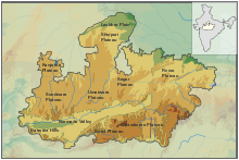
Different area-wise divisions of Madhya Pradesh:-
Area-wise, the state is divided into 10 broad divisions of Bhopal, Gwalior, Chambal, Hoshangabad, Indore, Rewa, Jabalpur, Sagar, Ujjain and Shahdol. However, in total, Madhya Pradesh comprises of 50 districts, which are Anuppur, Balaghat, Alirajpur, Ashoknagar, Betul, Barwani, Bhopal, Burhanpur, Bhind, Chhatarpur, Chhindwara, Damoh, Datia, Dindori, Dewas, Dhar, Gwalior, Guna, Harda, Hoshangabad, Indore, Jabalpur, Katni, Jhabua, Khargone, Mandla, Khandwa, Mandsaur, Neemuch, Morena, Narsinghpur, Raisen, Panna, Ratlam, Rewa, Rajgarh, Sagar, Seoni, Satna, Sehore, Shajapur, Shahdol, Shivpuri, Sidhi, Sheopur, Singrauli, Umaria, Tikamgarh, Vidisha and Ujjain. The vast area of Madhya Pradesh makes it one of the largest states in India. It is located at the heart of the country. The area of Madhya Pradesh has been estimated to be 443,446 square kilometers. The entire area of Madhya Pradesh has been politically divided into 45 districts with Bhopal as its capital. The total strength of the population inhabiting the area is around 66.1 million out of which around 34 millions are males and the rest are females. The people occupying the vast area of Madhya Pradesh have a literacy rate of 43.45% and the most widely spoken language is Hindi.Apart from the valleys of the Narmada and the Tapti, the area of Madhya Pradesh has a plateau region in between the mountains of the Vindhya and the Satpura ranges.
Topographical condition of Madhya Pradesh:-
Geography of Madhya Pradesh comprises three main physical divisions namely Central Highland, Satpura and Maikal Ranges and Eastern Highland. The triangular plateau between the Narmada and Son valleys and the Aravalli range is called the middle highland. It includes Vindhyan Escarpment, the Plateau of Bundelkhand, the Plateau of Central India, the Malwa Plateau and the Valley of the Narmada and the Son River. The northern boundary of the middle highland is formed by the river Yamuna. The maximum part of this plateau is the northern part of the Narmada and Son Rivers, which is a part of the Vindhyachal, Bhander and Kaimur ranges. The maximum height of the Vindhyachal hills is about 881 metres from mean average sea level. It is low towards the east. The height of the Bhander and Kaimur ranges are 752 metres and 686 metres respectively. The main rivers, which flow towards the north and join the Yamuna River, are Chambal River, Betwa River and Ken River.This division of central highland also consists of Vindhyan Escarpment, Bundelkhand Plateau, Plateau of Middle India, Malwa Plateau and Narmada-Son Valley. Vindhyan Escarpment is triangular plateau region. Bhander and Kaimur escarpments are found in the south and southeast. The river Son flows in the south, in parallel with the Kaimur range. The northern boundary of the plateau is the Vindhyan escarpment. On the way to Allahabad from Rewa district, there is a downward slope. The northern escarpment is continued by the Parma range, which extends up to Sagarin the southwest. The middle land of the Vindhyan escarpment is plain plateau, where streams deposit soil. This part is composed of the plateaus of Sagar, Damoh and Rewa. There is widespread land where stony soil is found in the surface. All the soil-dominated regions are characterised by agricultural practices. While forest is found in the stony land there are some patches without forest. The main river flowing in this region is the Ken and its tributaries.Further, the northern part of the middle highland is the Bundelkhand plateau, which is composed of Chhatarpur district, Tikamgarh, the maximum part of Datia and some part of Shivpuri district and Guna district. In addition, Lalitpur district, Jhansi district, Banda district and Jalon districts are also included in this plateau. This plateau is an eroded layer of Bundelkhand Gneiss of old rocks. The Yamuna River forms its boundary and in the other parts, Vindhyachal group rocks are found. The middle Indian plateau is located in the western part of the Bundelkhand plateau. This region comprises the Vindhyan rock group. This is separated by the Aravalli ranges in the west as a frontier fault. The Chambal valley is one of the main parts of this plateau, which is formed by alluvial statement. The Deccan Trap land to the south of the Narmada River is known as the Malwa Plateau. This is the western part of the Middle highland. Sagar binds this in the east. Vindhyan rocks are seen on the surface in its western part as an effect of erosion. The Vindhyan ranges are the southern boundary of this plateau. In the north, it extends up to Guna. This plateau is formed due to the solidification of volcanic explosion. Thus, the soil is black or regur soil, which is highly fertile for agriculture. In the south, black soil layer is thicker than in the north. Narmada-Son valley has the longest part in Madhya Pradesh, which is about 300 metres elevated from mean sea level. This is a narrow valley, which extends from the west to the northeast. Most of it is formed as an escarpment to the south of the Son valley. Flat land is also found in the Narmada valley, which is composed of dark black soil. Alluvial soil is found in the vicinity of the river while in the upper belt, red and laterite soils are found. The second major division of the geography of Madhya Pradesh is the Satpura-Maikal Range. The Satpura-Maikal range is divided into three parts namely west Satpura range, east Satpura range and Maikal range and plateau. West Satpura range is narrow and steep slop land, which extends up to Gujarat and Burhanpur Pass on the western boundary. There are many hills found in this range. East Satpura range is quite broad. It starts from Burhanpur pass towards the east, and is further divided into several subdivisions. The northern part of the Satpura range is quite broad. This part is called the plateau of Maikal. The eastern boundary is a crescent, which extends towards the south and this part is known as the Maikal Range. The average height is 900 metres. The upper layer of this range is plain. This layer is covered with vegetation. The ground floor grasses are also grown in this layer. This range is the source of many streams, which flow in different directions. This range is made up of the Deccan Traps. The Narmada and Son rivers originate from the Amarkantak plateau, which is part of this range. Geography of Madhya Pradesh also includes a moderate climate. Mostly residual soils are found in the state.
Based on the climatic conditions and physical features, the topography of Madhya Pradesh includes the following agro-climatic zones:
- Northern Plain
- Narmada Valley
- Wainganga Valley
- Malwa Plateau

- Kaimur Plateau
- Nimar Plateau
- Vindhyan Plateau
- Jhabua Hills
- Satpura Hills
- Gird Region
- Bundelkhand Region
Among all of these above mentioned topographical regions of this Central Province, the Northern Plains experience an extreme type of climate. The distant location of these plains makes the places extremely hot during the summer season and extremely cold in the time of winter. As compared to those areas, the climatic conditions of the hills of the Vindhyas are bit better. Neither the region becomes unbearably hot during summers, nor excessively cold during winter. The well known health resorts of Panchmarhi and Amarkantak are located in this region. Similar to the Northern Plains, the Narmada River Valley is even featured with very warm weather in summers and cold weather in the winters. The region of the Malwa plateau has got a very moderate kind of temperature throughout the year. Thus, the area does not become too hot in the summers or too cold during the winters. The plain lands of Chhattisgarh becomes quite hot in the summer days, though does not become that much cold in the winter times. However, owing to the rainfall, the Bastar mountainous area has got a humid and cold type of climate.
MPPCS Notes brings Prelims and Mains programs for MPPCS Prelims and MPPCS Mains Exam preparation. Various Programs initiated by MPPCS Notes are as follows:-- MPPCS Mains 2024 Tests and Notes Program
- MPPCS Prelims Exam 2024- Test Series and Notes Program
- MPPCS Prelims and Mains 2024 Tests Series and Notes Program
- MPPCS Detailed Complete Prelims Notes